The rain didn’t just fall; it poured with a ferocity that turned the familiar landscapes of Sumatra and Aceh into unrecognizable expanses of water and mud. In late November, as the skies opened up, communities in Aceh, North Sumatra, and West Sumatra faced one of the most severe ecological challenges in recent history. Rivers swelled, hillsides gave way, and for thousands of families, “home” became a memory submerged under two meters of floodwater.
At ASLI, we believe that technology finds its highest purpose when it serves humanity. And sometimes, when the roads are cut off and the ground is too treacherous to tread, help must come from a different perspective.
The View from Above
While rescue teams like the Human Initiative and government agencies heroically battled the mud on the ground, our geospatial partner, GeoSquareAI, turned their “eyes” to the sky.
In the midst of the chaos, information is as critical as food and medicine. Where is the damage worst? Which roads are passable? Which watersheds are overflowing? To answer these questions, GeoSquareAI activated their advanced satellite imagery analysis.
Mapping the Invisible Path
Using their precision technology—capable of dividing the vast Indonesian archipelago into detailed 50mx50m grids—GeoSquareAI began to piece together the puzzle of the disaster. They didn’t just see water; they saw data.
Their systems analyzed over 118 affected watersheds across the region. By processing satellite images through their AI models, they were able to:
- Identify Critical Zones: Pinpoint exactly where the floodwaters had inundated villages in Aceh and North Sumatra.
- Trace the Damage: Map out the 26 national road points and bridges that had been severed, providing crucial intelligence for logistics teams trying to deliver aid.
- Predict and Protect: Analyze the flow of the water to help predict which areas might be hit next, allowing for smarter, faster decision-making.
Collaborating with Planet Labs for high-resolution satellite imagery, the team at GeoSquareAI has mapped not just the extent of the damage, but the mechanics behind it.
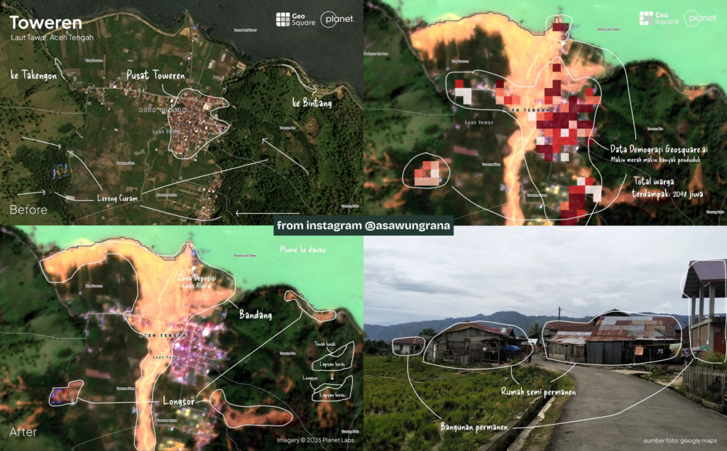
The Mechanics of a Landslide
The “Before and After” imagery of Toweren is stark. It captures exactly how the region’s geography turned deadly under the weight of heavy rainfall.
- Steep Slopes (“Lereng Curam”): The heavy rains destabilized the steep hills characteristic of the region, triggering massive landslides.
- The Path of Destruction: The resulting debris didn’t just slide; it flowed. This created a vast “alluvial fan deposition zone”—a fan-shaped spread of mud and rock that buried areas which were previously settled or cultivated.
- Into the Lake: The force of the slide sent a significant sediment plume crashing directly into Lake Laut Tawar, altering the landscape in a matter of moments.
Quantifying the Human Cost
Technology is most powerful when it sees the people behind the pixels. GeoSquareAI didn’t just map the mud; they overlaid their demographic data onto the disaster footprint to understand who was hurting.
- 2,048 Lives Impacted: In the analyzed section alone, GeoSquareAI estimates that
2,048 residents are directly in the path of the debris flow.
- Vulnerable Homes: The analysis confirmed that the “deep red” zones—areas with the highest population density—are inhabited by a mix of permanent and semi-permanent housing, all of which are highly vulnerable to this kind of flow.
- Ongoing Struggle: We know that numerous villages around the lake are currently facing power outages and severe flooding.
Technology for Good
This isn’t just about maps or data points; it’s about the people waiting for help in Aceh Tamiang, in Sibolga, and in the highlands of West Sumatra. By providing a clear, real-time picture of the disaster zone, GeoSquareAI is helping to ensure that relief efforts aren’t flying blind. They are ensuring that aid gets to where it is needed most, faster and more efficiently.
At ASLI, we are incredibly proud to stand beside a partner like GeoSquareAI. In the face of nature’s fury, they have shown us that while we cannot always stop the rain, we can use our intelligence and our technology to weather the storm together.
To our brothers and sisters in Sumatra: You are not alone. We are watching, we are working, and we are with you.